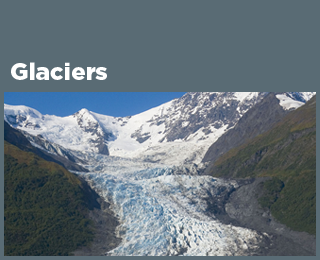
Climate Change Indicators: Arctic Glaciers
This indicator shows the cumulative change in the mass balance of Arctic glaciers.
Key Points
- Since 1945, the 12 Arctic glaciers in Figure 1 have experienced a decline in mass balance overall. One exception to this pattern is Engabreen, near the subpolar zone along the coast of Norway, which gained mass for much of the period of measurement and has about the same mass now that it did in its earliest measurements. Engabreen is more strongly influenced by precipitation than glaciers elsewhere in the Arctic, which may partly explain this change in pattern.5 This trend is anomalous and does not reflect the significant global loss of land ice as measured and catalogued from numerous glaciers elsewhere in the Arctic and around the world in the 20th century.6
- The loss of land-based ice in the Arctic has accelerated in recent decades. The Arctic is the largest contributing source of land ice to global sea level rise.7
Background
Rapid changes are occurring across the Arctic, where air temperatures are warming three times as fast as the global average temperature.1 The loss of land-based ice in the Arctic has accelerated in recent decades, and since at least 1972, the Arctic has been the dominant source of global sea-level rise.1 Greenland is the largest contributor to global sea-level rise from Arctic land ice, followed by small glaciers.1 If increases in greenhouse gas concentrations continue at current rates, it is expected that many of the smallest glaciers across the Arctic would disappear entirely by mid-century.2,3 As the Glaciers indicator explains, glaciers are important as an indicator of climate change and provide visible evidence of changes in temperature and precipitation.
Retreating glaciers and thawing permafrost in the Arctic are creating local and regional hazards that disrupt lives and livelihoods, infrastructure, sustainable development, and national security.4
About the Indicator
The indicator focuses on a set of 12 routinely measured glaciers at a latitude of 66°N or higher with data back to at least 1989—in one case, 1945. Figure 1 shows the cumulative mass balance of these glaciers from 1945 to 2023. This measurement of mass balance is consistent with EPA’s Glaciers indicator, just focusing in this case on 12 routinely measured glaciers north of the Arctic Circle. “Mass balance” refers to the net gain or loss of snow and ice (accumulation versus melting, sublimation, and calving). The measurements are in meters of water equivalent, which reflects the mass loss of the glacier by representing changes in the glacier’s average thickness. Cumulative change is determined from the base year of 1989, the first year in which all 12 glaciers had annual mass balance data.
About the Data
Indicator Notes
The relationship between climate change and glacier mass balance is complex, and the observed changes at specific reference glaciers reflect a combination of global and local variations in temperature and precipitation. Individual glaciers also vary in their structure, flow, and response to climate. Slightly different measurement and analysis methods have been used at different glaciers, but overall trends are similar.
Long-term measurements are available for only a very small percentage of the world’s glaciers. This indicator does not include the Greenland and Antarctic ice sheets, although two decades of satellite data suggest that these ice sheets are also experiencing a net loss of ice (see the Ice Sheets indicator).9 Continued satellite data collection will allow scientists to evaluate long-term trends in the future.
Data Sources
The World Glacier Monitoring Service compiled data for Figure 1, based on measurements collected by a variety of organizations around the world. Historical data, as well as periodic reports and measurements of the reference glaciers, are available at: https://wgms.ch. This indicator can also be found at: www.globalchange.gov/indicators.
Technical Documentation
References
1. AMAP (Arctic Monitoring and Assessment Programme). (2021). AMAP Arctic climate change update 2021: Key trends and impacts. www.amap.no/documents/download/6890/inline
2. AMAP (Arctic Monitoring and Assessment Programme). (2017). Snow, water, ice and permafrost in the Arctic: Summary for policy-makers. www.amap.no/documents/doc/snow-water-ice-and-permafrost.-summary-for-policy-makers/1532
3. AMAP (Arctic Monitoring and Assessment Programme). (2019). Arctic climate change update 2019: An update to Key Findings of Snow, Water, Ice and Permafrost in the Arctic (SWIPA) 2017. www.amap.no/documents/doc/amap-climate-change-update-2019/1761
4. Wolken, G. J., Liljedahl, A. K., Brubaker, M., Coe, J. A., Fiske, G., Christiansen, H. H., Jacquemart, M., Jones, B. M., Kääb, A., Løvholt, F., Natali, S., Rudy, A. C. A., & Streletskiy, D. (2021). Glacier and permafrost hazards. In NOAA (National Oceanic and Atmospheric Administration), Arctic report card: Update for 2021. https://arctic.noaa.gov/report-card/report-card-2021/glacier-and-permafrost-hazards
5. Paul, F., & Andreassen, L. M. (2009). A new glacier inventory for the Svartisen region, Norway, from Landsat ETM+ data: Challenges and change assessment. Journal of Glaciology, 55(192), 607–618. https://doi.org/10.3189/002214309789471003
6. Pfeffer, W. T., Arendt, A. A., Bliss, A., Bolch, T., Cogley, J. G., Gardner, A. S., Hagen, J.-O., Hock, R., Kaser, G., Kienholz, C., Miles, E. S., Moholdt, G., Mölg, N., Paul, F., Radić, V., Rastner, P., Raup, B. H., Rich, J., Sharp, M. J., & The Randolph Consortium. (2014). The Randolph Glacier Inventory: A globally complete inventory of glaciers. Journal of Glaciology, 60(221), 537–552. https://doi.org/10.3189/2014JoG13J176
7. Box, J. E., Colgan, W. T., Christensen, T. R., Schmidt, N. M., Lund, M., Parmentier, F.-J. W., Brown, R., Bhatt, U. S., Euskirchen, E. S., Romanovsky, V. E., Walsh, J. E., Overland, J. E., Wang, M., Corell, R. W., Meier, W. N., Wouters, B., Mernild, S., Mård, J., Pawlak, J., & Olsen, M. S. (2019). Key indicators of Arctic climate change: 1971–2017. Environmental Research Letters, 14(4), 045010. https://doi.org/10.1088/1748-9326/aafc1b
8. WGMS (World Glacier Monitoring Service). (2024). Fluctuations of Glaciers database. https://wgms.ch/data_databaseversions
9. IPCC (Intergovernmental Panel on Climate Change). (2019). Summary for policymakers. In The ocean and cryosphere in a changing climate: Special report of the Intergovernmental Panel on Climate Change. Cambridge University Press. https://doi.org/10.1017/9781009157964.001
Learn about other indicators in this section